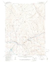
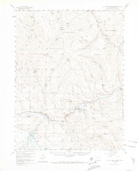
1957 Map of Hot Sulphur Springs
USGS Topo · Published 1963About this map
Hot Sulphur Springs serves as the focal point for this mid-century survey of the Grand County landscape, where the Colorado River carves through the dramatic Byers Canyon. The town’s position at the river's bend, combined with the presence of the Denver and Rio Grande Western railroad, reflects the vital transportation and recreation corridor of the 1950s. The map illustrates a high-country economy transition, where traditional cattle operations like the Wheatley Ranch and East Forks Cow Camp coexist with early leisure destinations such as the Drowsy Water Ranch. To the south, the recently filled Williams Fork Reservoir and its associated Johnson Lateral irrigation system highlight the era's significant water management projects. Peaks such as Mount Bross and Searight Mountain tower over the Arapaho National Forest, while infrastructure like a Radio Relay Station and a Gaging Sta signal the arrival of modern technological monitoring in the Colorado Rockies.
Find a feature on this map
54 named features on this map. Tap any name to fly to it.
Don’t see what you’re looking for? This feature index may not catch every label — zoom into the map to look around manually.
Map Details
Editions of this 1957 Hot Sulphur Springs Map
6 editions found

Other maps of this area

1915 · Longs Peak
USGS Topo · 1:125,000

1919 · Rocky Mountain National Park
USGS Topo · 1:125,000

1924 · Fraser
USGS Topo · 1:62,500

1926 · Fraser
USGS Topo · 1:62,500

1933 · Mt. Powell
USGS Topo · 1:48,000

1933 · Ute Peak
USGS Topo · 1:62,500

1937 · Ute Peak
USGS Topo · 1:62,500

1940 · Mount Powell
USGS Topo · 1:62,500

1953 · Denver
USGS Topo · 1:250,000

1954 · Greeley
USGS Topo · 1:250,000