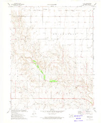
1973 Map of Hough
USGS Topo · Published 1975About this map
Hough serves as the focal point for this survey of the Oklahoma Panhandle, captured at a time when the energy industry dominated the local landscape. The expansive Carthage Gas and Oil Field is documented in detail, with scores of Gas Wells and Oil Wells peppered across the High Plains. This industrial footprint is interspersed with rural infrastructure such as a Lookout Tower and a Drag Strip located near the southern edge of the quadrangle.
Find a feature on this map
20 named features on this map. Tap any name to fly to it.
Don’t see what you’re looking for? This feature index may not catch every label — zoom into the map to look around manually.
Map Details
Editions of this 1973 Hough Map
This is the sole edition of this map. No revisions or reprints were ever made.
Other maps of this area

1954 · Perryton
USGS Topo · 1:250,000

1958 · Perryton
USGS Topo · 1:250,000

1967 · Straight
USGS Topo · 1:24,000

1967 · Straight SW
USGS Topo · 1:24,000

1968 · Guymon
USGS Topo · 1:24,000

1973 · Goodwell NW
USGS Topo · 1:24,000

1973 · Hough SW
USGS Topo · 1:24,000

1973 · Hough NE
USGS Topo · 1:24,000

1973 · Goodwell NE
USGS Topo · 1:24,000

1973 · Hough NW
USGS Topo · 1:24,000