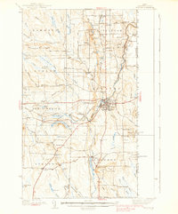
1938 Map of Houlton
USGS Topo · Published 1938About this map
Houlton serves as the bustling commercial and international hub of southern Aroostook County in the late 1930s, defined by its position at the intersection of the Canadian Pacific railway and critical road networks. The landscape is dotted with small agricultural and rural school districts, including Porter Settlement, Carys Mills, and Jackins Settlement, reflecting a period of decentralized local education with schoolhouses like McBride Sch and Logan Sch serving outlying farms.
Find a feature on this map
96 named features on this map. Tap any name to fly to it.
Don’t see what you’re looking for? This feature index may not catch every label — zoom into the map to look around manually.
Map Details
Editions of this 1938 Houlton Map
3 editions found
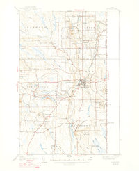
Other maps of this area

1934 · Bridgewater
USGS Topo · 1:48,000

1935 · Howe Brook
USGS Topo · 1:48,000

1937 · Smyrna Mills
USGS Topo · 1:62,500

1938 · Bridgewater
USGS Topo · 1:62,500

1938 · Houlton
USGS Topo · 1:62,500

1939 · Howe Brook
USGS Topo · 1:62,500

1940 · Amity
USGS Topo · 1:62,500

1941 · Amity
USGS Topo · 1:62,500

1941 · Mattawamkeag Lake
USGS Topo · 1:62,500

1943 · Amity
USGS Topo · 1:62,500