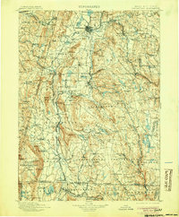
1900 Map of Housatonic
USGS Topo · Published 1905About this map
The Housatonic River valley serves as the central artery for this late 19th-century survey, anchoring a network of industrial and agricultural communities across the tri-state border of Massachusetts, New York, and Connecticut. This era finds the region deeply connected by rail, with the Boston and Albany R. R. cutting through the northern highlands while the New York New Haven and Hartford R. R. follows the river's path south through Great Barrington.
Find a feature on this map
185 named features on this map. Tap any name to fly to it.
Don’t see what you’re looking for? This feature index may not catch every label — zoom into the map to look around manually.
Map Details
Editions of this 1900 Housatonic Map
5 editions found

Other maps of this area

1885 · Sheffield
USGS Topo · 1:62,500

1886 · Greylock
USGS Topo · 1:62,500

1886 · Hawley
USGS Topo · 1:62,500

1886 · Chesterfield
USGS Topo · 1:62,500

1886 · Becket
USGS Topo · 1:62,500

1887 · Granville
USGS Topo · 1:62,500

1888 · Sheffield
USGS Topo · 1:62,500

1888 · Becket
USGS Topo · 1:62,500

1888 · Berlin
USGS Topo · 1:62,500

1888 · Sandisfield
USGS Topo · 1:62,500