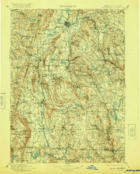
1900 Map of Housatonic
USGS Topo · Published 1920About this map
The Housatonic River corridor serves as the primary axis for this late 19th-century survey, anchoring a landscape of industrial hamlets and Gilded Age retreats. The river facilitates a series of manufacturing nodes, from the iron works at Richmond Furnace to the paper-making centers at Lee and South Lee. The rail network of the Housatonic Division and the B. & A. R. R. follows these natural watercourses, connecting established towns like Great Barrington and Pittsfield with smaller junction points such as Van Deusenville.
Find a feature on this map
168 named features on this map. Tap any name to fly to it.
Don’t see what you’re looking for? This feature index may not catch every label — zoom into the map to look around manually.
Map Details
Editions of this 1900 Housatonic Map
5 editions found

Other maps of this area

1885 · Sheffield
USGS Topo · 1:62,500

1886 · Greylock
USGS Topo · 1:62,500

1886 · Hawley
USGS Topo · 1:62,500

1886 · Chesterfield
USGS Topo · 1:62,500

1886 · Becket
USGS Topo · 1:62,500

1887 · Granville
USGS Topo · 1:62,500

1888 · Sheffield
USGS Topo · 1:62,500

1888 · Becket
USGS Topo · 1:62,500

1888 · Berlin
USGS Topo · 1:62,500

1888 · Sandisfield
USGS Topo · 1:62,500