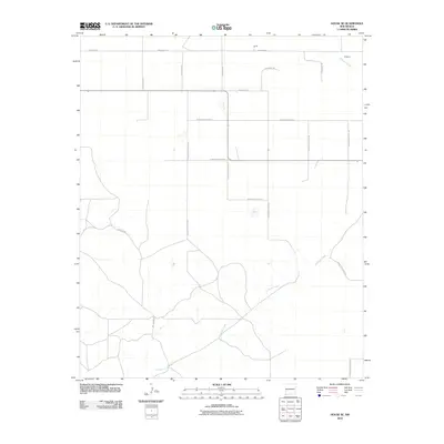
2010 Map of House SE
USGS Topo · Published 2010About this map
Alamosa Creek winds through the southeastern plains of New Mexico, carving a path through an arid landscape defined by its grid of rural ranch roads. In the northern reaches of this territory, the small settlements of Smith and Ferguson sit near the border between Quay and Roosevelt counties. The map captures the infrastructure of the High Plains, where long, straight thoroughfares like Quay Road 25 and N Roosevelt Road 22 facilitate travel between remote ranching properties. Local landmarks such as Hill Ranch Rd and Mitchell Rd signify the presence of established cattle operations in this open country. The drainage patterns of the creek and its intermittent tributaries provide the primary topographic relief in an otherwise expansive, organized survey of the western range.
Find a feature on this map
21 named features on this map. Tap any name to fly to it.
Don’t see what you’re looking for? This feature index may not catch every label — zoom into the map to look around manually.
Map Details
Editions of this 2010 House SE Map
This is the sole edition of this map. No revisions or reprints were ever made.
Other maps of this area

1954 · Clovis
USGS Topo · 1:250,000

1957 · Melrose
USGS Topo · 1:62,500

1958 · Clovis
USGS Topo · 1:250,000

1973 · Tolar
USGS Topo · 1:24,000

1973 · Weber City
USGS Topo · 1:24,000

1973 · Krider
USGS Topo · 1:24,000

1973 · House
USGS Topo · 1:24,000

1973 · Melrose West
USGS Topo · 1:24,000
1973 · Peach Canyon
USGS Topo · 1:24,000

1973 · Mc Alister
USGS Topo · 1:24,000