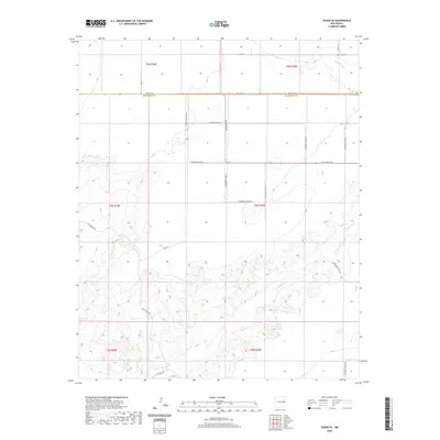
2020 Map of House SE
USGS Topo · Published 2020About this map
Alamosa Cr meanders through this landscape, defining the rugged drainage patterns that break the high plains of Eastern New Mexico. The terrain is structured by the prominent Quay Co Roosevelt Co boundary line, which divides the northern and southern portions of the sheet. The local transportation network is dominated by a grid of rural routes such as N Roosevelt Road Au and New Mexico 89, while specialized corridors like Hill Ranch Rd and Franklin Rd suggest the region's ranching and agricultural heritage. The contour lines reveal a topography of deep draws and high plateaus, particularly around the northern reaches of the creek, illustrating how the physical environment has historically dictated the placement of roads and property boundaries in this high-desert region.
Find a feature on this map
26 named features on this map. Tap any name to fly to it.
Don’t see what you’re looking for? This feature index may not catch every label — zoom into the map to look around manually.
Map Details
Editions of this 2020 House SE Map
This is the sole edition of this map. No revisions or reprints were ever made.
Other maps of this area

1954 · Clovis
USGS Topo · 1:250,000

1957 · Melrose
USGS Topo · 1:62,500

1958 · Clovis
USGS Topo · 1:250,000

1973 · Tolar
USGS Topo · 1:24,000

1973 · Weber City
USGS Topo · 1:24,000

1973 · Krider
USGS Topo · 1:24,000

1973 · House
USGS Topo · 1:24,000

1973 · Melrose West
USGS Topo · 1:24,000
1973 · Peach Canyon
USGS Topo · 1:24,000

1973 · Mc Alister
USGS Topo · 1:24,000