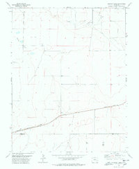
1978 Map of Houston Lakes
USGS Topo · Published 1978About this map
Houston Lakes and the surrounding high plains of southeastern Colorado appear here during the mid-1970s. This arid landscape is defined by the ephemeral waters of Sand Arroyo and Mustang Creek, which cut across the prairie toward the southeast. The small settlement of Heath serves as the primary focal point of human activity, situated along the southern edge of the quadrangle where the Missouri Pacific railroad corridor establishes a vital transport link through the region. The map reveals a land divided by administrative boundaries where Kiowa, Otero, and Bent counties meet, showing a sparse network of section lines and isolated wells that indicate the area's agricultural and ranching foundations. Researchers will find a clear record of the intersection between these county lines and the industrial presence of the railway before further modern development altered the remote local character.
Find a feature on this map
13 named features on this map. Tap any name to fly to it.
Don’t see what you’re looking for? This feature index may not catch every label — zoom into the map to look around manually.
Map Details
Editions of this 1978 Houston Lakes Map
2 editions found
Other maps of this area

1891 · Catlin
USGS Topo · 1:125,000

1891 · Las Animas
USGS Topo · 1:125,000

1893 · Las Animas
USGS Topo · 1:125,000

1893 · Catlin
USGS Topo · 1:125,000

1954 · Meredith Hill
USGS Topo · 1:24,000

1954 · Lamar
USGS Topo · 1:250,000

1955 · Mc Intosh Ranch
USGS Topo · 1:24,000
1955 · Lewis Ranch
USGS Topo · 1:24,000

1958 · Lamar
USGS Topo · 1:250,000

1974 · Arlington NE
USGS Topo · 1:24,000