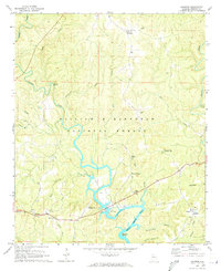
1969 Map of Houston
USGS Topo · Published 1973About this map
The William B Bankhead National Forest dominates the upper half of this terrain, where the deeply carved channels of the Sipsey Fork and its numerous tributaries like Payne Creek and Grindstone Creek create a complex drainage network. To the south, the landscape is defined by the winding reaches of Lewis Smith Lake, featuring distinctive water-bound landmarks such as Beasley Bend. This 1969 survey captures the area as it balanced conservation and utility, shown by the proximity of the Natural Bridge Recreation Area to the County Municipal Airport. Small rural centers such as Moreland and Houston serve as anchor points for local history, connected by a web of country roads that pass by established community landmarks including Barnett Chapel, Adair Chapel, and the New Home Ch.
Find a feature on this map
35 named features on this map. Tap any name to fly to it.
Don’t see what you’re looking for? This feature index may not catch every label — zoom into the map to look around manually.
Map Details
Editions of this 1969 Houston Map
2 editions found
Other maps of this area

1935 · Upshaw
USGS Topo · 1:24,000

1935 · Danville
USGS Topo · 1:48,000

1936 · Moulton
USGS Topo · 1:48,000

1938 · Danville
USGS Topo · 1:62,500

1940 · Mt Hope
USGS Topo · 1:62,500

1956 · Gadsden
USGS Topo · 1:250,000

1958 · Gadsden
USGS Topo · 1:250,000

1960 · Gadsden
USGS Topo · 1:250,000
1960 · Bee Branch
USGS Topo · 1:24,000
1960 · Grayson
USGS Topo · 1:24,000