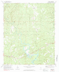
1969 Map of Houston
USGS Topo · Published 1985About this map
The William B Bankhead National Forest dominates this Winston County landscape, showing the rugged topography of north Alabama before the 1980s. The southern portion of the map is defined by the winding reaches of Lewis Smith Lake, including the distinctive Beasley Bend. The settlement of Houston serves as a focal point for local history, featuring Memorial Ch and nearby cemeteries. Further north, the isolated community of Moreland is marked by a Lookout Tower and New Home Ch, indicating the high-elevation vantage points of the region. The map also traces the intricate drainage systems of Sipsey Fork and Brushy Creek, which carve through the forest. Evidence of mid-century infrastructure is visible at the County Municipal Airport and the Natural Bridge Recreation Area, reflecting a mix of conservation and rural development during this era.
Find a feature on this map
37 named features on this map. Tap any name to fly to it.
Don’t see what you’re looking for? This feature index may not catch every label — zoom into the map to look around manually.
Map Details
Editions of this 1969 Houston Map
2 editions found
Other maps of this area

1935 · Upshaw
USGS Topo · 1:24,000

1935 · Danville
USGS Topo · 1:48,000

1936 · Moulton
USGS Topo · 1:48,000

1938 · Danville
USGS Topo · 1:62,500

1940 · Mt Hope
USGS Topo · 1:62,500

1956 · Gadsden
USGS Topo · 1:250,000

1958 · Gadsden
USGS Topo · 1:250,000

1960 · Gadsden
USGS Topo · 1:250,000
1960 · Bee Branch
USGS Topo · 1:24,000
1960 · Grayson
USGS Topo · 1:24,000