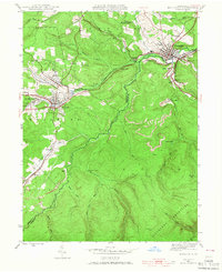
1944 Map of Houtzdale
USGS Topo · Published 1967About this map
Houtzdale and Osceola Mills anchor this 1944 survey of the Moshannon Creek valley, revealing a landscape defined by coal-era settlement patterns and rail infrastructure. The map documents the tight-knit residential clusters of Brisbin, West Moshannon, and Morann, which grew to support the local extractive industries. Steep terrain is navigated by numerous rail lines and junctions, such as Goss Run Junc, while the Allegheny Mountains dominate the southern portion of the quadrangle. Local educational history is preserved through the locations of Beaver Sch and Ocean Sch, serving families in outlying patches like Parsonsville and Stumptown. Natural resource management is evident at the Osceola Res and the Fire Tower stationed atop the higher elevations of Pumping Station Mountain. The meandering path of Moshannon Creek serves as the boundary between Clearfield and Centre counties, separating the townships of Decatur, Woodward, and Rush.
Find a feature on this map
46 named features on this map. Tap any name to fly to it.
Don’t see what you’re looking for? This feature index may not catch every label — zoom into the map to look around manually.
Map Details
Editions of this 1944 Houtzdale Map
5 editions found
Other maps of this area

1903 · Houtzdale
USGS Topo · 1:62,500

1905 · Houtzdale
USGS Topo · 1:62,500

1920 · Altoona
USGS Topo · 1:62,500

1922 · Philipsburg
USGS Topo · 1:62,500

1922 · Altoona
USGS Topo · 1:62,500

1923 · Tyrone
USGS Topo · 1:62,500

1929 · Tyrone
USGS Topo · 1:48,000

1933 · Tyrone
USGS Topo · 1:62,500

1939 · Philipsburg
USGS Topo · 1:62,500

1944 · Houtzdale
USGS Topo · 1:24,000