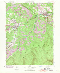
1944 Map of Houtzdale
USGS Topo · Published 1970About this map
Houtzdale and Osceola Mills anchor this mid-century topographic record of the Moshannon Valley coal region. The landscape is defined by the Penn Central rail network, which connects numerous small mining and industrial settlements like West Moshannon, Sterling, and Spike Island. The map illustrates a developed rural infrastructure through named educational sites such as Ocean Sch and Beaver Sch, alongside essential utilities like the Pumping Station and the Fire Tower near Herder Spr.
Find a feature on this map
44 named features on this map. Tap any name to fly to it.
Don’t see what you’re looking for? This feature index may not catch every label — zoom into the map to look around manually.
Map Details
Editions of this 1944 Houtzdale Map
5 editions found
Other maps of this area

1903 · Houtzdale
USGS Topo · 1:62,500

1905 · Houtzdale
USGS Topo · 1:62,500

1920 · Altoona
USGS Topo · 1:62,500

1922 · Philipsburg
USGS Topo · 1:62,500

1922 · Altoona
USGS Topo · 1:62,500

1923 · Tyrone
USGS Topo · 1:62,500

1929 · Tyrone
USGS Topo · 1:48,000

1933 · Tyrone
USGS Topo · 1:62,500

1939 · Philipsburg
USGS Topo · 1:62,500

1944 · Houtzdale
USGS Topo · 1:24,000