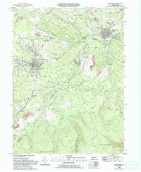
1993 Map of Houtzdale
USGS Topo · Published 1994About this map
The industrial legacy of the Clearfield County coalfields is etched across this landscape, where numerous Strip Mines and drill holes surround the borough of Houtzdale. The map illustrates a dense network of mountain settlements including Osceola Mills, Brisbin, and Sterling, many of which developed alongside the Conrail lines and former rail corridors noted as Old Railroad Grade. This late twentieth-century survey reveals the proximity of residential areas like New Town and Stumptown to the active and former extractive sites that once drove the local economy.
Find a feature on this map
44 named features on this map. Tap any name to fly to it.
Don’t see what you’re looking for? This feature index may not catch every label — zoom into the map to look around manually.
Map Details
Editions of this 1993 Houtzdale Map
2 editions found
Other maps of this area

1903 · Houtzdale
USGS Topo · 1:62,500

1905 · Houtzdale
USGS Topo · 1:62,500

1920 · Altoona
USGS Topo · 1:62,500

1922 · Philipsburg
USGS Topo · 1:62,500

1922 · Altoona
USGS Topo · 1:62,500

1923 · Tyrone
USGS Topo · 1:62,500

1929 · Tyrone
USGS Topo · 1:48,000

1933 · Tyrone
USGS Topo · 1:62,500

1939 · Philipsburg
USGS Topo · 1:62,500

1944 · Houtzdale
USGS Topo · 1:24,000