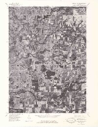
1976 Map of Howard City NW
USGS Topo · Published 1979About this map
Morley and Howard City anchor this orthophotoquad, which uses 1976 aerial photography to document the landscape of western Montcalm County. The imagery reveals the intricate, winding course of the Little Muskegon River as it cuts through a patchwork of agricultural fields and woodlots. South of the river, the village of Amble sits at a rural crossroads, while the larger grid of Howard City is visible near the confluence of Tamarack Creek. This specialized photograph-based map provides a literal view of land use and vegetation patterns just as the region’s modern road network was becoming firmly established, offering a stark contrast between the dense wooded wetlands of the river valleys and the cleared, rectangular farmsteads that dominate the higher ground.
Find a feature on this map
5 named features on this map. Tap any name to fly to it.
Don’t see what you’re looking for? This feature index may not catch every label — zoom into the map to look around manually.
Map Details
Editions of this 1976 Howard City NW Map
This is the sole edition of this map. No revisions or reprints were ever made.
Other maps of this area

1954 · Midland
USGS Topo · 1:250,000

1958 · Midland
USGS Topo · 1:250,000

1958 · Sand Lake
USGS Topo · 1:62,500

1958 · Woodville
USGS Topo · 1:62,500

1958 · Big Rapids
USGS Topo · 1:62,500

1959 · Midland
USGS Topo · 1:250,000

1959 · Howard City
USGS Topo · 1:62,500

1966 · Midland
USGS Topo · 1:250,000

1976 · Big Rapids SE
USGS Topo · 1:24,000

1976 · Big Rapids SW
USGS Topo · 1:24,000