
1921 Map of Howard
USGS Topo · Published 1966About this map
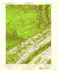
The Pennsylvania Railroad tracks run along the base of Bald Eagle Mountain, serving as a vital transportation corridor connecting the settlements of Howard and Blanchard. This landscape is defined by the steep transition from the dense drainage networks of the north, including Tangascootack Creek and Baker Run, to the broad, agricultural opening of the Nittany Valley in the south. The distribution of neighborhood institutions is particularly dense here, with numerous rural schoolhouses such as the Madden Run School and Bitner School serving isolated hollows and timbering communities.
Find a feature on this map
84 named features on this map. Tap any name to fly to it.
Don’t see what you’re looking for? This feature index may not catch every label — zoom into the map to look around manually.
Map Details
Editions of this 1921 Howard Map

Historical Maps of Lamar Through Time
43 maps found
1921 Howard
Clinton County, PA

1923 Howard
Clinton County, PA

1943 Hyner
Clinton County, PA

1946 Glen Union
Clinton County, PA

1946 Hammersley Fork
Clinton County, PA

1946 Keating
Clinton County, PA

1946 Renovo East
Clinton County, PA

1946 Renovo East
Clinton County, PA

1946 Renovo West
Clinton County, PA

1946 Renovo West
Clinton County, PA

1946 Tamarack
Clinton County, PA

1946 Young Womans Creek
Clinton County, PA

1948 Glen Union
Clinton County, PA

1948 Hammersley Fork
Clinton County, PA

1948 Keating
Clinton County, PA

1948 Renovo East
Clinton County, PA

1948 Tamarack
Clinton County, PA

1949 Renovo West
Clinton County, PA

1949 Young Womans Creek
Clinton County, PA

1959 Pottersdale
Clinton County, PA

1960 Snow Shoe NE
Clinton County, PA

1965 Carroll
Clinton County, PA

1966 Farrandsville
Clinton County, PA

1967 Beech Creek
Clinton County, PA

1967 Howard NW
Clinton County, PA

1977 Beech Creek
Clinton County, PA

1984 Williamsport West
Clinton County, PA

1994 Hammersley Fork
Clinton County, PA

1994 Tamarack
Clinton County, PA

1994 Young Womans Creek
Clinton County, PA

2023 Beech Creek
Clinton County, PA

2023 Carroll
Clinton County, PA

2023 Farrandsville
Clinton County, PA

2023 Glen Union
Clinton County, PA

2023 Hammersley Fork
Clinton County, PA

2023 Howard NW
Clinton County, PA

2023 Keating
Clinton County, PA

2023 Pottersdale
Clinton County, PA

2023 Renovo East
Clinton County, PA

2023 Renovo West
Clinton County, PA

2023 Snow Shoe NE
Clinton County, PA

2023 Tamarack
Clinton County, PA

2023 Young Womans Creek
Clinton County, PA