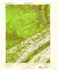
1921 Map of Howard
USGS Topo · Published 1958About this map
The West Branch Susquehanna River cuts a prominent path through the northern reaches of this central Pennsylvania landscape, serving as a corridor for the Pennsylvania Railroad. The topography is defined by the sharp transition from the steep, stream-carved ridges of Bald Eagle Mountain to the fertile agricultural stretches of Nittany Valley. Settlements like Howard and Beech Creek anchor a network of small rural communities connected by the New York Central Railroad and established road systems.
Find a feature on this map
78 named features on this map. Tap any name to fly to it.
Don’t see what you’re looking for? This feature index may not catch every label — zoom into the map to look around manually.
Map Details
Editions of this 1921 Howard Map
Other maps of this area

1908 · Bellefonte
USGS Topo · 1:62,500

1909 · Bellefonte
USGS Topo · 1:62,500

1921 · Howard
USGS Topo · 1:48,000

1921 · Lock Haven
USGS Topo · 1:62,500

1923 · Howard
USGS Topo · 1:62,500

1923 · Lock Haven
USGS Topo · 1:62,500

1924 · Centre Hall
USGS Topo · 1:62,500

1928 · Snow Shoe
USGS Topo · 1:48,000

1929 · Centre Hall
USGS Topo · 1:62,500

1931 · Show Shoe
USGS Topo · 1:62,500