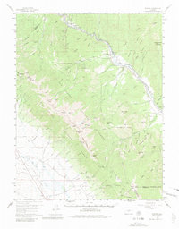
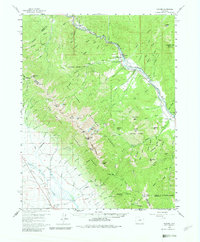
1959 Map of Howard
USGS Topo · Published 1981About this map
The Arkansas River corridor serves as the primary artery for transport and industry in this portion of the Sangre de Cristo Mountains during the late 1950s. The Denver and Rio Grande Western Railroad tracks closely follow the river's winding path, connecting small mountain settlements like Wellsville, Swissvale, and Howard. The presence of several quarries near Calcite and Howard indicates the area's ongoing reliance on mineral extraction, while local civic life is anchored by the Stout Creek Sch, Howard Community Ch, and Howard Cem. To the southwest, the high-altitude terrain of the San Isabel National Forest is mapped with extensive trail systems, including the Rainbow Trail and San Isabel Trail, which wind past prominent summits like Bushnell Peak and Mount Otto. This survey captures a moment when the rugged canyon floor supported a cohesive network of rail-dependent communities and seasonal mountain camps like Hayden Creek Campground.
Find a feature on this map
117 named features on this map. Tap any name to fly to it.
Don’t see what you’re looking for? This feature index may not catch every label — zoom into the map to look around manually.
Map Details
Editions of this 1959 Howard Map
6 editions found

Other maps of this area

1950 · Valley View Hot Springs
USGS Topo · 1:24,000

1954 · Pueblo
USGS Topo · 1:250,000

1956 · Cameron Mountain
USGS Topo · 1:62,500

1956 · Poncha Springs
USGS Topo · 1:62,500

1956 · Montrose
USGS Topo · 1:250,000

1957 · Pueblo
USGS Topo · 1:250,000

1958 · Pueblo
USGS Topo · 1:250,000

1959 · Montrose
USGS Topo · 1:250,000

1959 · Electric Peak
USGS Topo · 1:62,500

1959 · Bonanza
USGS Topo · 1:62,500