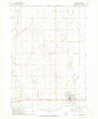
1971 Map of Howard
USGS Topo · Published 1973About this map
The West Fork Vermillion River meanders through this agricultural landscape in Miner County, which in the early 1970s was defined by its railroad intersections and small prairie settlements. Howard serves as a significant hub on the Chicago Milwaukee St Paul and Pacific line, featuring local landmarks such as the Golf Course, Graceland Cem, and the Howard Municipal Airport. Further north, the town of Carthage and the smaller village of Vilas sit along the Chicago and North Western tracks.
Find a feature on this map
20 named features on this map. Tap any name to fly to it.
Don’t see what you’re looking for? This feature index may not catch every label — zoom into the map to look around manually.
Map Details
Editions of this 1971 Howard Map
This is the sole edition of this map. No revisions or reprints were ever made.
Other maps of this area
1899 · Alexandria
USGS Topo · 1:125,000
1899 · De Smet
USGS Topo · 1:125,000

1953 · Watertown
USGS Topo · 1:250,000

1955 · Sioux Falls
USGS Topo · 1:250,000

1958 · Sioux Falls
USGS Topo · 1:250,000
1958 · Watertown
USGS Topo · 1:250,000
1968 · Oldham SW
USGS Topo · 1:24,000
1968 · Oldham NW
USGS Topo · 1:24,000
1971 · Howard NE
USGS Topo · 1:24,000
1971 · Carthage
USGS Topo · 1:24,000