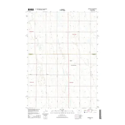
2015 Map of Howard NE
USGS Topo · Published 2015About this map
Cloverleaf Colony and the agricultural lands of Kingsbury and Miner Counties define this rural landscape on the edge of the Coteau des Prairies. The terrain is characterized by a high concentration of glacial wetlands and depressions, drained by the meandering path of the W Fork Vermillion River and Rock Cr. The map reveals a strictly organized grid of rural roads, such as 220th St and CR-4, which provide access to isolated farmsteads and specialized sites like the Lee Airport. This 2015 survey reflects a classic Great Plains settlement pattern where the natural hydrology of the Coteau intersects with a rigid township and range system, highlighting the long-standing importance of water management and transport in eastern South Dakota.
Find a feature on this map
19 named features on this map. Tap any name to fly to it.
Don’t see what you’re looking for? This feature index may not catch every label — zoom into the map to look around manually.
Map Details
Editions of this 2015 Howard NE Map
This is the sole edition of this map. No revisions or reprints were ever made.
Other maps of this area

1899 · De Smet
USGS Topo · 1:125,000

1953 · Watertown
USGS Topo · 1:250,000

1958 · Watertown
USGS Topo · 1:250,000

1968 · Oldham SW
USGS Topo · 1:24,000

1968 · Lake Preston West
USGS Topo · 1:24,000

1968 · Oldham NW
USGS Topo · 1:24,000

1971 · Howard NE
USGS Topo · 1:24,000

1971 · De Smet SE
USGS Topo · 1:24,000

1971 · Howard
USGS Topo · 1:24,000
1971 · Carthage
USGS Topo · 1:24,000