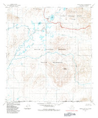
1984 Map of Howard Pass A-2
USGS Topo · Published 1984About this map
The Howard Pass sits at the northern edge of the Noatak National Preserve in the early 1980s, marking a significant boundary between the North Slope Borough and the protected lands to the south. This remote arctic landscape is defined by its massive drainage systems and topographical shifts, where the Aniuk River and Etivluk River carve paths through the tundra toward the Howard Hills. The map details the administrative overlap of the National Petroleum Reserve in Alaska and the Noatak Wilderness, illustrating the complex management of public lands in the Brooks Range. Notable peaks such as Likhkluk Mountain and Rough Mountain overlook a network of seasonal waters including Flora Creek, Fauna Creek, and several significant lakes like Akuliak Lake and Nigtun Lake, which dot the northern plains.
Find a feature on this map
16 named features on this map. Tap any name to fly to it.
Don’t see what you’re looking for? This feature index may not catch every label — zoom into the map to look around manually.
Map Details
Editions of this 1984 Howard Pass A-2 Map
This is the sole edition of this map. No revisions or reprints were ever made.
Other maps of this area

1951 · Howard Pass
USGS Topo · 1:250,000

1951 · Ambler River
USGS Topo · 1:250,000

1956 · Howard Pass
USGS Topo · 1:250,000

1956 · Ambler River
USGS Topo · 1:250,000

1964 · Ambler River
USGS Topo · 1:250,000
1984 · Howard Pass B-1
USGS Topo · 1:63,360
1984 · Howard Pass B-2
USGS Topo · 1:63,360
1984 · Howard Pass A-1
USGS Topo · 1:63,360

1984 · Howard Pass A-3
USGS Topo · 1:63,360

1984 · Howard Pass B-3
USGS Topo · 1:63,360