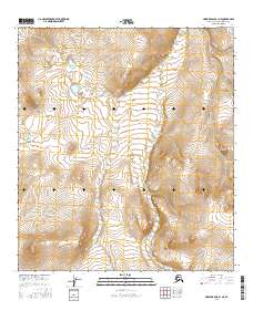
2016 Map of Howard Pass B-1 NE
USGS Topo · Published 2016About this map
Kutchaurak Cr winds through this expanse of the North Slope, serving as the primary drainage for the surrounding terrain. The landscape is defined by the rigid grid of the Public Land Survey System, including t11s r19w, t11s r18w, t12s r19w, and t12s r18w. This 2016 survey emphasizes the topographical relief of the Brooks Range foothills, where dramatic contour lines reveal a series of ridges and valleys. The placement of these boundaries over such an unpopulated area illustrates the systematic effort by the U.S. Geological Survey and the BLM to categorize and manage the vast, remote stretches of the Alaska North Slope Borough. For the researcher, the map provides a precise look at the drainage patterns and elevations that dictate movement and land use in this arctic environment.
Find a feature on this map
5 named features on this map. Tap any name to fly to it.
Don’t see what you’re looking for? This feature index may not catch every label — zoom into the map to look around manually.
Map Details
Editions of this 2016 Howard Pass B-1 NE Map
This is the sole edition of this map. No revisions or reprints were ever made.
Other maps of this area

1951 · Howard Pass
USGS Topo · 1:250,000

1951 · Killik River
USGS Topo · 1:250,000

1956 · Howard Pass
USGS Topo · 1:250,000

1956 · Killik River
USGS Topo · 1:250,000
1984 · Killik River B-5
USGS Topo · 1:63,360
1984 · Howard Pass B-1
USGS Topo · 1:63,360

1984 · Howard Pass C-1
USGS Topo · 1:63,360
1984 · Killik River C-5
USGS Topo · 1:63,360
2016 · Howard Pass C-1 SW
USGS Topo · 1:25,000
2016 · Howard Pass B-1 NW
USGS Topo · 1:25,000