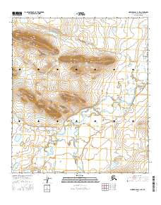
2016 Map of Howard Pass C-1 SW
USGS Topo · Published 2016About this map
The confluence of high-latitude waterways and prominent arctic landforms takes center stage in this 2016 survey of the North Slope. The Etivluk River meanders across the eastern half of the map, fed by the Nigu River which cuts through the southern reaches. These drainage patterns are defined by significant elevations, most notably the high ground of Lisburne Ridge in the northwest and Puvakrat Mtn further south. The landscape is marked by the complex topography of the Brooks Range foothills, where seasonal waters like Tukuto Cr drain into the primary river systems. The lack of any man-made structures or road networks underscores the wilderness character of this remote Alaskan terrain, focusing purely on the hydrologic and geologic features that govern the region.
Find a feature on this map
11 named features on this map. Tap any name to fly to it.
Don’t see what you’re looking for? This feature index may not catch every label — zoom into the map to look around manually.
Map Details
Editions of this 2016 Howard Pass C-1 SW Map
This is the sole edition of this map. No revisions or reprints were ever made.
Other maps of this area

1951 · Howard Pass
USGS Topo · 1:250,000

1956 · Howard Pass
USGS Topo · 1:250,000
1984 · Howard Pass B-1
USGS Topo · 1:63,360

1984 · Howard Pass C-1
USGS Topo · 1:63,360
1984 · Howard Pass C-2
USGS Topo · 1:63,360
1984 · Howard Pass B-2
USGS Topo · 1:63,360
2016 · Howard Pass B-2 NE
USGS Topo · 1:25,000
2016 · Howard Pass C-2 SE
USGS Topo · 1:25,000
2016 · Howard Pass B-1 NW
USGS Topo · 1:25,000
2016 · Howard Pass C-1 NW
USGS Topo · 1:25,000