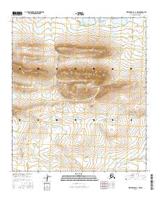
2016 Map of Howard Pass C-1 NW
USGS Topo · Published 2016About this map
Smith Mtn and Kingak Mtn dominate the northern landscape of this North Slope interior region, rising above a high-altitude terrain defined by glacial features and drainage patterns. The northern edge of the sheet is marked by the Smith Mountain Lakes, a collection of alpine water bodies that drain southward into the Medial Cr system. This area, largely untouched by infrastructure or permanent settlement, is documented here through precise elevation contouring that reveals the complex structure of the Brooks Range foothills. The map provides a detailed record of the Public Land Survey System divisions, including Township 8 South, Range 20 West, which help orient researchers to specific land blocks in this wilderness environment.
Find a feature on this map
8 named features on this map. Tap any name to fly to it.
Don’t see what you’re looking for? This feature index may not catch every label — zoom into the map to look around manually.
Map Details
Editions of this 2016 Howard Pass C-1 NW Map
This is the sole edition of this map. No revisions or reprints were ever made.
Other maps of this area

1951 · Howard Pass
USGS Topo · 1:250,000

1956 · Howard Pass
USGS Topo · 1:250,000

1984 · Howard Pass D-1
USGS Topo · 1:63,360

1984 · Howard Pass C-1
USGS Topo · 1:63,360
1984 · Howard Pass C-2
USGS Topo · 1:63,360
1984 · Howard Pass D-2
USGS Topo · 1:63,360
2016 · Howard Pass C-2 SE
USGS Topo · 1:25,000
2016 · Howard Pass D-1 SE
USGS Topo · 1:25,000
2016 · Howard Pass D-1 SW
USGS Topo · 1:25,000
2016 · Howard Pass C-1 SW
USGS Topo · 1:25,000