
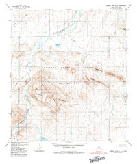
1984 Map of Howard Pass D-1
USGS Topo · Published 1984About this map
The Colville River and its major tributaries dominate this 1980s landscape within the National Petroleum Reserve in Alaska. This portion of the North Slope reflects a complex drainage system where the Ipnavik River and Etivluk River converge toward the larger Colville basin. The map reveals the intricate braided patterns and oxbow lakes characteristic of the Arctic coastal plain's southern reaches, including the Smith Mountain Lakes and the winding course of the East Fork.
Find a feature on this map
8 named features on this map. Tap any name to fly to it.
Don’t see what you’re looking for? This feature index may not catch every label — zoom into the map to look around manually.
Map Details
Editions of this 1984 Howard Pass D-1 Map
This is the sole edition of this map. No revisions or reprints were ever made.
Other maps of this area

1951 · Lookout Ridge
USGS Topo · 1:250,000

1951 · Ikpikpuk River
USGS Topo · 1:250,000

1951 · Howard Pass
USGS Topo · 1:250,000

1951 · Killik River
USGS Topo · 1:250,000

1956 · Lookout Ridge
USGS Topo · 1:250,000

1956 · Howard Pass
USGS Topo · 1:250,000

1956 · Killik River
USGS Topo · 1:250,000

1956 · Ikpikpuk River
USGS Topo · 1:250,000

1984 · Howard Pass C-1
USGS Topo · 1:63,360
1984 · Howard Pass C-2
USGS Topo · 1:63,360