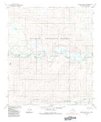
1984 Map of Howard Pass D-2
USGS Topo · Published 1984About this map
The National Petroleum Reserve in Alaska dominates this 1970s-era landscape, where the braided channels of the Colville River cut through the northern tundra. This survey documents a vast, roadless wilderness defined by hydraulic patterns and topographical markers rather than human settlements. The drainage network is particularly detailed, showing the seasonal Okroknakpak Lakes and the winding course of the Ipnavik River in the southern portion of the quadrangle.
Find a feature on this map
8 named features on this map. Tap any name to fly to it.
Don’t see what you’re looking for? This feature index may not catch every label — zoom into the map to look around manually.
Map Details
Editions of this 1984 Howard Pass D-2 Map
This is the sole edition of this map. No revisions or reprints were ever made.
Other maps of this area

1951 · Lookout Ridge
USGS Topo · 1:250,000

1951 · Howard Pass
USGS Topo · 1:250,000

1956 · Lookout Ridge
USGS Topo · 1:250,000

1956 · Howard Pass
USGS Topo · 1:250,000

1984 · Howard Pass D-1
USGS Topo · 1:63,360

1984 · Howard Pass C-1
USGS Topo · 1:63,360
1984 · Howard Pass C-2
USGS Topo · 1:63,360
1984 · Howard Pass D-3
USGS Topo · 1:63,360

1984 · Howard Pass C-3
USGS Topo · 1:63,360
1984 · Lookout Ridge A-1
USGS Topo · 1:63,360