
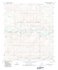
1984 Map of Howard Pass C-3
USGS Topo · Published 1984About this map
The National Petroleum Reserve in Alaska dominates this landscape, showing a vast wilderness of the North Slope in the early 1980s. The northern reaches are characterized by the Kuna River and the prominent Monument Ridge, which stretches across the central portion of the quadrangle. This topography illustrates the complex drainage patterns of the arctic tundra, where numerous named tributaries such as Cutaway Creek, Lost Temper Creek, and Cula Creek carve through the high ground. To the south, the terrain becomes more defined with notable elevations including Mount Bupto, Rim Butte, and the distinctively named Pimple Peak. The map provides a precise record of these landforms before significant modern changes, tracing watercourses like Bushy Creek and Crassico Creek as they navigate the ridges and valleys of this remote region.
Find a feature on this map
13 named features on this map. Tap any name to fly to it.
Don’t see what you’re looking for? This feature index may not catch every label — zoom into the map to look around manually.
Map Details
Editions of this 1984 Howard Pass C-3 Map
This is the sole edition of this map. No revisions or reprints were ever made.
Other maps of this area

1951 · Howard Pass
USGS Topo · 1:250,000

1956 · Howard Pass
USGS Topo · 1:250,000
1984 · Howard Pass D-4
USGS Topo · 1:63,360
1984 · Howard Pass C-2
USGS Topo · 1:63,360
1984 · Howard Pass B-2
USGS Topo · 1:63,360
1984 · Howard Pass D-3
USGS Topo · 1:63,360
1984 · Howard Pass D-2
USGS Topo · 1:63,360

1984 · Howard Pass B-4
USGS Topo · 1:63,360

1984 · Howard Pass C-4
USGS Topo · 1:63,360

1984 · Howard Pass B-3
USGS Topo · 1:63,360