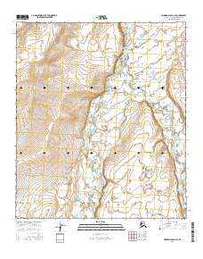
2016 Map of Howard Pass D-1 SE
USGS Topo · Published 2016About this map
The Etivluk River winds through this expanse of the North Slope, joined from the east by its namesake tributary. The landscape is defined by the braided channels and numerous small kettle ponds typical of the Arctic tundra, where the East Fork Etivluk River meets the main stem. This 2016 survey illustrates the hydrographic complexity of the region, showing how the river systems navigate the subtle elevation changes of the western Brooks Range foothills. The absence of roads or permanent settlements within the survey area reflects the remote character of this part of Alaska, where the environment is shaped entirely by seasonal water cycles and the natural topography of the river basins.
Find a feature on this map
10 named features on this map. Tap any name to fly to it.
Don’t see what you’re looking for? This feature index may not catch every label — zoom into the map to look around manually.
Map Details
Editions of this 2016 Howard Pass D-1 SE Map
This is the sole edition of this map. No revisions or reprints were ever made.
Other maps of this area

1951 · Howard Pass
USGS Topo · 1:250,000

1951 · Killik River
USGS Topo · 1:250,000

1956 · Howard Pass
USGS Topo · 1:250,000

1956 · Killik River
USGS Topo · 1:250,000

1984 · Howard Pass D-1
USGS Topo · 1:63,360

1984 · Howard Pass C-1
USGS Topo · 1:63,360

1984 · Killik River D-5
USGS Topo · 1:63,360
1984 · Killik River C-5
USGS Topo · 1:63,360
2016 · Howard Pass D-1 SW
USGS Topo · 1:25,000
2016 · Howard Pass D-1 NW
USGS Topo · 1:25,000