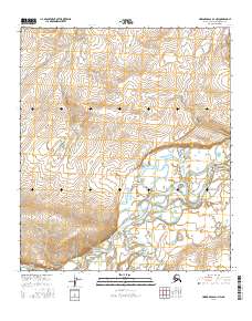
2016 Map of Howard Pass D-1 NW
USGS Topo · Published 2016About this map
Colville River dominates this Arctic landscape, carving a wide path through the North Slope as it flows eastward. This specific stretch of the drainage reveals the intricate braided nature of the channel and the broad, low-lying gravel bars that characterize the region's major waterways. To the south, the Ipnavik River converges with the main stem, creating a complex network of smaller seasonal channels and wetlands that define the local hydrology. The surrounding terrain is organized by the Public Land Survey System, with grid lines for t5s r20w, t5s r19w, t6s r20w, and t6s r19w providing structural points of reference across an otherwise roadless and uninhabited territory. This map serves as a primary record of the shifting river morphologies and elevation contours of the Brooks Range foothills before further environmental change.
Find a feature on this map
6 named features on this map. Tap any name to fly to it.
Don’t see what you’re looking for? This feature index may not catch every label — zoom into the map to look around manually.
Map Details
Editions of this 2016 Howard Pass D-1 NW Map
This is the sole edition of this map. No revisions or reprints were ever made.
Other maps of this area

1951 · Lookout Ridge
USGS Topo · 1:250,000

1951 · Howard Pass
USGS Topo · 1:250,000

1956 · Lookout Ridge
USGS Topo · 1:250,000

1956 · Howard Pass
USGS Topo · 1:250,000

1984 · Howard Pass D-1
USGS Topo · 1:63,360
1984 · Howard Pass D-2
USGS Topo · 1:63,360
1984 · Lookout Ridge A-1
USGS Topo · 1:63,360
1984 · Lookout Ridge A-2
USGS Topo · 1:63,360
2016 · Howard Pass D-1 SE
USGS Topo · 1:25,000
2016 · Howard Pass D-2 NE
USGS Topo · 1:25,000