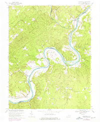
1968 Map of Howardsville
USGS Topo · Published 1975About this map
The James River carves a deep, winding path through the borderlands of Nelson, Albemarle, and Buckingham Counties, defining the agricultural and industrial life of the region. The river is dotted with significant landforms like Sycamore Island, Buford Island, and Dog Island, which sit amidst a landscape of sharp ridges and creek valleys. Transport and commerce follow the water, anchored by the Chesapeake and Ohio railroad which parallels the riverbank, serving riverfront settlements like Howardsville, Warminster, and Wingina.
Find a feature on this map
39 named features on this map. Tap any name to fly to it.
Don’t see what you’re looking for? This feature index may not catch every label — zoom into the map to look around manually.
Map Details
Editions of this 1968 Howardsville Map
3 editions found
Other maps of this area

1892 · Buckingham
USGS Topo · 1:125,000

1929 · Covesville
USGS Topo · 1:62,500

1935 · Covesville
USGS Topo · 1:62,500

1943 · Lovingston
USGS Topo · 1:62,500

1945 · Covesville
USGS Topo · 1:62,500

1946 · Lovingston
USGS Topo · 1:62,500

1947 · Roanoke
USGS Topo · 1:250,000

1959 · Roanoke
USGS Topo · 1:250,000

1961 · Shipman
USGS Topo · 1:62,500

1961 · Buckingham
USGS Topo · 1:62,500