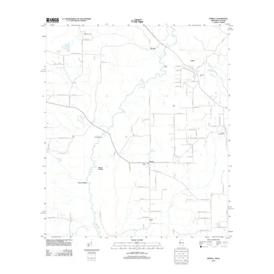
2012 Map of Howell
USGS Topo · Published 2012About this map
The Escatawpa River defines the rural character of this borderland area, winding past small river landings and established settlements. In the southern portion of the sheet, Howell serves as a local hub, situated near several family and community burial grounds including Howell Cem and Midway Cem. To the north, the terrain transitions toward Latonia and Moffet, where the land is carved by Scarbo Cr and Rocky Cr. Genealogists and local historians will find significant value in the distribution of small cemeteries such as Moffetville Cem and Ward Cem, which are scattered among a network of rural routes like Shipman Firetower Rd. The landscape also supports distinct community spaces, from the Gulf Coast Bible Camp in the northwest to the aviation activity at Evans Field Airport in the east.
Find a feature on this map
99 named features on this map. Tap any name to fly to it.
Don’t see what you’re looking for? This feature index may not catch every label — zoom into the map to look around manually.
Map Details
Editions of this 2012 Howell Map
This is the sole edition of this map. No revisions or reprints were ever made.
Other maps of this area

1941 · Hurley
USGS Topo · 1:62,500

1941 · Vancleave
USGS Topo · 1:62,500

1941 · Lucedale
USGS Topo · 1:62,500

1942 · Wilmer
USGS Topo · 1:62,500

1943 · Lucedale
USGS Topo · 1:62,500

1943 · Hurley
USGS Topo · 1:62,500

1943 · Vancleave
USGS Topo · 1:62,500

1944 · Wilmer
USGS Topo · 1:62,500

1944 · Vancleave
USGS Topo · 1:62,500

1953 · Mobile
USGS Topo · 1:250,000