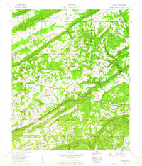
1959 Map of Howelton
USGS Topo · Published 1961About this map
Straight Mountain and Blount Mountain dominate this corner of Etowah County, where the Tennessee Valley Authority mapped a landscape defined by parallel ridges and fertile coves. Small farming communities and family settlements are tucked into the valleys, including Howelton, Aurora, and Egypt. Local life in the late 1950s centered around numerous rural congregations such as New Welcome Church, Morton Chapel, and Mt Olive Ch. The southwestern portion of the map is defined by Greasy Cove and Little Cove, while transportation and commerce follow the corridor of the Louisville and Nashville railroad. Genealogists can locate several family and community burial grounds, including the Howelton Cem and Armstrong Cem, providing a detailed record of the families who settled these upland valleys before modern development.
Find a feature on this map
44 named features on this map. Tap any name to fly to it.
Don’t see what you’re looking for? This feature index may not catch every label — zoom into the map to look around manually.
Map Details
Editions of this 1959 Howelton Map
2 editions found
Other maps of this area

1885 · Gadsden
USGS Topo · 1:125,000

1888 · Gadsden
USGS Topo · 1:125,000

1889 · Springville
USGS Topo · 1:125,000

1892 · Springville
USGS Topo · 1:125,000

1892 · Gadsden
USGS Topo · 1:125,000

1895 · Gadsden
USGS Topo · 1:125,000

1903 · Gadsden
USGS Topo · 1:125,000

1936 · Mountainboro
USGS Topo · 1:24,000

1936 · Rodentown
USGS Topo · 1:24,000

1936 · High Point
USGS Topo · 1:24,000