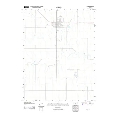
2009 Map of Hoxie
USGS Topo · Published 2009About this map
Hoxie serves as the central hub of this Sheridan County landscape, where the street grid of Main St and Oak Ave meets the surrounding High Plains terrain. The town's local history is anchored by the Hoxie Cemetery to the north and Saint Francis Cemetery to the west, providing valuable points of reference for genealogical research. Water drainage patterns are defined by Sand Creek, which meanders south of the main settlement, and the South Fork Solomon River as it cuts across the southwestern portion of the quadrangle. The presence of the Hoxie Municipal Airport and a network of rural routes like Co Rd 406 illustrates the modern infrastructure supporting this agricultural region. The map reveals how the early 21st-century town layout remains closely tied to its natural waterways and regional transport corridors.
Find a feature on this map
10 named features on this map. Tap any name to fly to it.
Don’t see what you’re looking for? This feature index may not catch every label — zoom into the map to look around manually.
Map Details
Editions of this 2009 Hoxie Map
This is the sole edition of this map. No revisions or reprints were ever made.
Other maps of this area

1954 · Goodland
USGS Topo · 1:250,000

1956 · Goodland
USGS Topo · 1:250,000

1957 · Goodland
USGS Topo · 1:250,000

1979 · Midway Draw West
USGS Topo · 1:24,000

1979 · Midway Draw East
USGS Topo · 1:24,000

1979 · Hoxie
USGS Topo · 1:24,000

1979 · Hoxie NE
USGS Topo · 1:24,000
1979 · Rexford NE
USGS Topo · 1:24,000

1979 · Grinnell NE
USGS Topo · 1:24,000

1979 · Tasco
USGS Topo · 1:24,000