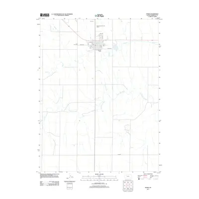
2012 Map of Hoxie
USGS Topo · Published 2012About this map
Hoxie serves as a central hub for Sheridan County, where the street grid is organized around the intersection of Sheridan St and several numbered avenues. This 2012 survey illustrates the town's layout between the winding path of Sand Cr and the more significant drainage of the S Fork Solomon River to the south. Local heritage is preserved at sites like Saint Francis Cem on the western edge and Hoxie Cem to the north, near the Hoxie-Sheridan County Airport. The map shows a landscape defined by agricultural road patterns, including Co Rd-406, which bridge the gap between the town center and the surrounding river valley. Public utilities and infrastructure, such as the Hoxie Wastewater Treatment Facility, are clearly marked, providing a detailed look at the modern municipal footprint in this western Kansas community.
Find a feature on this map
22 named features on this map. Tap any name to fly to it.
Don’t see what you’re looking for? This feature index may not catch every label — zoom into the map to look around manually.
Map Details
Editions of this 2012 Hoxie Map
This is the sole edition of this map. No revisions or reprints were ever made.
Other maps of this area

1954 · Goodland
USGS Topo · 1:250,000

1956 · Goodland
USGS Topo · 1:250,000

1957 · Goodland
USGS Topo · 1:250,000

1979 · Midway Draw West
USGS Topo · 1:24,000

1979 · Midway Draw East
USGS Topo · 1:24,000

1979 · Hoxie
USGS Topo · 1:24,000

1979 · Hoxie NE
USGS Topo · 1:24,000
1979 · Rexford NE
USGS Topo · 1:24,000

1979 · Grinnell NE
USGS Topo · 1:24,000

1979 · Tasco
USGS Topo · 1:24,000