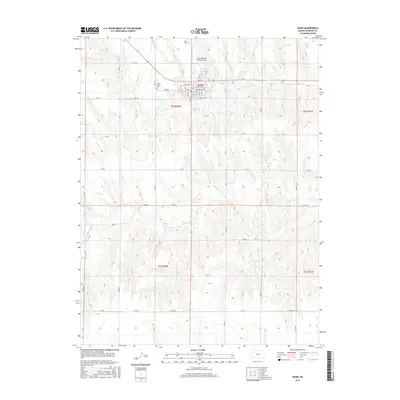
2015 Map of Hoxie
USGS Topo · Published 2015About this map
The town of Hoxie serves as the central hub for Sheridan County on this 2015 survey, situated in the northwestern corner of the quadrangle. The community's organized street grid includes thoroughfares like Main St, Queen Ave, and Sheridan Ave, while the surrounding landscape is defined by the high plains of western Kansas. Cultural sites important for local genealogy and history are preserved at Hoxie Cem and Saint Francis Cem. Beyond the residential center, the Hoxie-Sheridan County Airport facilitates regional connectivity. The natural drainage of the area is governed by the meandering S Fork Solomon River and Sand Cr, which cut through the agricultural sections of t8s r28w and t9s r28w. This map illustrates the intersection of modern infrastructure and traditional land management in a critical rural Kansas settlement.
Find a feature on this map
42 named features on this map. Tap any name to fly to it.
Don’t see what you’re looking for? This feature index may not catch every label — zoom into the map to look around manually.
Map Details
Editions of this 2015 Hoxie Map
This is the sole edition of this map. No revisions or reprints were ever made.
Other maps of this area

1954 · Goodland
USGS Topo · 1:250,000

1956 · Goodland
USGS Topo · 1:250,000

1957 · Goodland
USGS Topo · 1:250,000

1979 · Midway Draw West
USGS Topo · 1:24,000

1979 · Midway Draw East
USGS Topo · 1:24,000

1979 · Hoxie
USGS Topo · 1:24,000

1979 · Hoxie NE
USGS Topo · 1:24,000
1979 · Rexford NE
USGS Topo · 1:24,000

1979 · Grinnell NE
USGS Topo · 1:24,000

1979 · Tasco
USGS Topo · 1:24,000