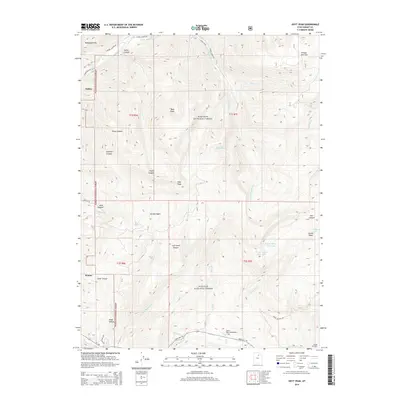
2014 Map of Hoyt Peak
USGS Topo · Published 2014About this map
Hoyt Peak serves as the literal high point of this terrain within the Wasatch National Forest, where the landscape is defined by a series of deep basins and canyons. The western edge of the map shows the edge of high-altitude settlement at Oakley and Kamas, where the transition from the valley floor to the wilderness is marked by Elder Hollow and Wide Hollow. The drainage network is complex, with the Weber River and S Fork Weber River carving paths through Swifts Canyon and Pinon Canyon. Higher elevations reveal glacial-sculpted features such as Castle Lake, Upper Yellow Pine Lake, and Lower Yellow Pine Lake. The presence of Shingle Mill Flat suggests the historical timber-related activity common in these mountains, while modern access is provided by State Hwy 150, which skirts the Yellow Pine Campground as it heads toward the interior of the range.
Find a feature on this map
47 named features on this map. Tap any name to fly to it.
Don’t see what you’re looking for? This feature index may not catch every label — zoom into the map to look around manually.
Map Details
Editions of this 2014 Hoyt Peak Map
This is the sole edition of this map. No revisions or reprints were ever made.
Other maps of this area

1885 · Salt Lake
USGS Topo · 1:250,000

1900 · Coalville
USGS Topo · 1:125,000

1903 · Coalville
USGS Topo · 1:125,000

1954 · Salt Lake City
USGS Topo · 1:250,000

1958 · Salt Lake City
USGS Topo · 1:250,000

1960 · Salt Lake City
USGS Topo · 1:250,000

1967 · Francis
USGS Topo · 1:24,000

1967 · Kamas
USGS Topo · 1:24,000
1967 · Crandall Canyon
USGS Topo · 1:24,000
1972 · Erickson Basin
USGS Topo · 1:24,000