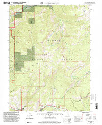
1998 Map of Hoyt Peak
USGS Topo · Published 2001About this map
The Weber River and its South Fork carve through the northern reach of the Wasatch National Forest, defining a high-elevation landscape of basins and canyons. Centered on the 10,228-foot Hoyt Peak, this area serves as a significant drainage for the Uinta foothills, with numerous seasonal and perennial flows including Maxwell Creek and Yellow Pine Creek. The small settlement of Samak sits at the southwestern edge, marking the transition from the valley floor into the timbered slopes. Evidence of long-standing recreational and timber use is visible in the placement of the Ponderosa Group Campground and the Shingle Mill Flat. The Mirror Lake Scenic Byway provides the primary transit artery, tracing the path of Beaver Creek and connecting the scattered trailheads and gaging stations that monitor this critical watershed.
Find a feature on this map
40 named features on this map. Tap any name to fly to it.
Don’t see what you’re looking for? This feature index may not catch every label — zoom into the map to look around manually.
Map Details
Editions of this 1998 Hoyt Peak Map
This is the sole edition of this map. No revisions or reprints were ever made.
Other maps of this area

1885 · Salt Lake
USGS Topo · 1:250,000

1900 · Coalville
USGS Topo · 1:125,000

1903 · Coalville
USGS Topo · 1:125,000

1954 · Salt Lake City
USGS Topo · 1:250,000

1958 · Salt Lake City
USGS Topo · 1:250,000

1960 · Salt Lake City
USGS Topo · 1:250,000

1967 · Francis
USGS Topo · 1:24,000

1967 · Kamas
USGS Topo · 1:24,000
1967 · Crandall Canyon
USGS Topo · 1:24,000
1972 · Erickson Basin
USGS Topo · 1:24,000