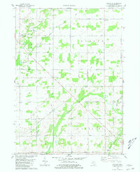
1980 Map of Hoytville
USGS Topo · Published 1981About this map
Hoytville and the surrounding townships of Roxand and Vermontville are depicted in this late-1970s landscape, characterized by a dense network of county highways and small rural settlements. The area is defined by its watercourses, notably the Thornapple River winding through the southern half and Sebewa Creek in the northwest. Local history is well-preserved through several small burial grounds, including Sunfield Cem, Welsh Cem, and Moyer Cem, which serve as anchors for the scattered farmsteads. The small hamlet of Little Venice marks a junction in the center of the sheet, while Gresham occupies the southeastern corner near the Little Thornapple River. Religious and educational sites like the Church of the Brethren and the Loucks Sch illustrate the community structure of Eaton County before further modern development altered these traditional township patterns.
Find a feature on this map
33 named features on this map. Tap any name to fly to it.
Don’t see what you’re looking for? This feature index may not catch every label — zoom into the map to look around manually.
Map Details
Editions of this 1980 Hoytville Map
This is the sole edition of this map. No revisions or reprints were ever made.
Other maps of this area

1916 · Ionia
USGS Topo · 1:62,500

1918 · Ionia
USGS Topo · 1:62,500

1943 · Ionia
USGS Topo · 1:62,500

1945 · Portland
USGS Topo · 1:62,500

1949 · Charlotte
USGS Topo · 1:62,500

1950 · Nashville
USGS Topo · 1:62,500

1951 · Nashville
USGS Topo · 1:62,500

1958 · Grand Rapids
USGS Topo · 1:250,000

1961 · Grand Rapids
USGS Topo · 1:250,000

1962 · Grand Rapids
USGS Topo · 1:250,000