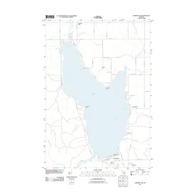
2011 Map of Hubbard Lake
USGS Topo · Published 2011About this map
Hubbard Lake dominates this Northeastern Michigan landscape, its deep waters framed by the prominent peaks of Mount Maria and Hickey Hill. By the early 21st century, the shoreline evolved into a concentrated recreational hub, particularly at the southern end near Backus Beach and the Mount Maria Ski Area. The map reveals a sophisticated network of residential and access roads, such as Bear Springs RD and Mount Maria RD, that serve the scattered lakeside communities. Significant geological and navigational features like Doctors Point, Churchill Point, and Hardwood Point divide the lake into distinct basins including North Bay, East Bay, and the shallower Mud Bay. Drainage patterns are clearly defined by the Lower S Br Thunder Bay River to the north and the West Branch River to the south, highlighting the area's role in the regional watershed.
Find a feature on this map
61 named features on this map. Tap any name to fly to it.
Don’t see what you’re looking for? This feature index may not catch every label — zoom into the map to look around manually.
Map Details
Editions of this 2011 Hubbard Lake Map
This is the sole edition of this map. No revisions or reprints were ever made.
Other maps of this area

1954 · Tawas City
USGS Topo · 1:250,000

1958 · Tawas City
USGS Topo · 1:250,000

1959 · Glennie
USGS Topo · 1:62,500

1959 · Harrisville
USGS Topo · 1:62,500

1971 · Spruce
USGS Topo · 1:24,000
1971 · Ossineke
USGS Topo · 1:24,000

1972 · Hubbard Lake
USGS Topo · 1:24,000

1972 · Hubbard Lake SW
USGS Topo · 1:24,000
1972 · Big Ravine Creek
USGS Topo · 1:24,000
1972 · Evans Creek
USGS Topo · 1:24,000