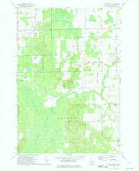
1972 Map of Evans Creek
USGS Topo · Published 1975About this map
The Thunder Bay River State Forest dominates this Alpena County landscape, where the Thunder Bay River winds through a dense network of tributaries and lowlands. The rural townships of Green, Wilson, and Ossineke are defined by a grid of farm-to-market roads, including Werth Road and Herron Road, which connect isolated homesteads and local civic landmarks. Genealogical interest is centered on the cluster of religious sites like St Matthew Ch, St Paul Ch, and Salem Ch, along with their associated burial grounds. The presence of numerous Gravel Pits and a Sandpit scattered across the township lines suggests a local economy tied to natural resource extraction and road building. Terrain features such as Smokey Hollow and the marshy expanses around Widner Creek illustrate the water-rich geography of the region during the early 1970s.
Find a feature on this map
41 named features on this map. Tap any name to fly to it.
Don’t see what you’re looking for? This feature index may not catch every label — zoom into the map to look around manually.
Map Details
Editions of this 1972 Evans Creek Map
This is the sole edition of this map. No revisions or reprints were ever made.
Other maps of this area

1954 · Tawas City
USGS Topo · 1:250,000

1954 · Alpena
USGS Topo · 1:250,000

1955 · Hillman
USGS Topo · 1:62,500

1957 · Alpena
USGS Topo · 1:250,000

1958 · Alpena
USGS Topo · 1:250,000

1958 · Tawas City
USGS Topo · 1:250,000

1969 · Alpena
USGS Topo · 1:250,000

1971 · Lake Winyah
USGS Topo · 1:24,000

1971 · Lachine
USGS Topo · 1:24,000

1972 · Hubbard Lake
USGS Topo · 1:24,000