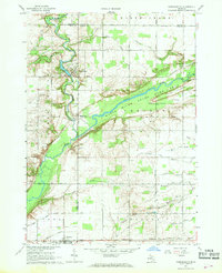
1967 Map of Hubbardston
USGS Topo · Published 1968About this map
Hubbardston sits at the confluence of Fish Creek and the Maple River, serving as a focal point for this rural landscape where Ionia, Clinton, Gratiot, and Montcalm counties meet. The mid-1960s terrain is defined by a complex drainage network, including the Sessions and Connors Drain and Ruel Drain, supporting the agricultural character of the North Plains and Bloomer regions. To the south, the village of Pewamo is anchored by the Grand Trunk railroad line and the Pewamo Cem. This survey illustrates the transition from cultivated fields to the protected wetlands of the Maple River State Game Area, which encompasses the distinctive topographic rise known as The Island. Local history is preserved through several rural burial grounds like East Plains Cem and the Most Holy Trinity Cem, alongside numerous gravel pits that reflect the area's geological and industrial utility during the late 1960s.
Find a feature on this map
52 named features on this map. Tap any name to fly to it.
Don’t see what you’re looking for? This feature index may not catch every label — zoom into the map to look around manually.
Map Details
Editions of this 1967 Hubbardston Map
This is the sole edition of this map. No revisions or reprints were ever made.
Other maps of this area

1918 · Perrinton
USGS Topo · 1:62,500

1927 · De Witt
USGS Topo · 1:62,500

1943 · Perrinton
USGS Topo · 1:62,500

1945 · Portland
USGS Topo · 1:62,500

1954 · Midland
USGS Topo · 1:250,000

1958 · Midland
USGS Topo · 1:250,000

1958 · Grand Rapids
USGS Topo · 1:250,000

1959 · Midland
USGS Topo · 1:250,000

1961 · Grand Rapids
USGS Topo · 1:250,000

1962 · Grand Rapids
USGS Topo · 1:250,000