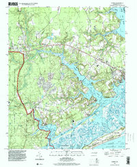
1997 Map of Hubert
USGS Topo · Published 2000About this map
The coastal transition of Onslow County is defined by the intersection of the White Oak River and the Intracoastal Waterway near the historic maritime hub of Swansboro. This late-century survey documents the landscape surrounding the eastern boundary of the Camp Lejeune Military Reservation, where the dense drainage networks of Queen Creek and Bear Creek meet the Atlantic. The map provides a detailed view of the barrier island topography at Bear Island, part of Hammocks Beach State Park, noting shifting sand dunes with elevations reaching up to 67 feet. Inland, the settlement patterns of Hubert and Piney Grove are visible alongside local landmarks like Oak Grove Ch, while the shoreline is dotted with traditional access points such as Shell Rock Landing and Great Neck Landing.
Find a feature on this map
38 named features on this map. Tap any name to fly to it.
Don’t see what you’re looking for? This feature index may not catch every label — zoom into the map to look around manually.
Map Details
Editions of this 1997 Hubert Map
This is the sole edition of this map. No revisions or reprints were ever made.
Other maps of this area

1942 · Maysville
USGS Topo · 1:62,500

1942 · Swansboro
USGS Topo · 1:62,500

1943 · Jacksonville
USGS Topo · 1:62,500

1948 · Maysville
USGS Topo · 1:62,500

1948 · Swansboro
USGS Topo · 1:62,500

1948 · New River
USGS Topo · 1:62,500

1952 · Hubert
USGS Topo · 1:24,000

1952 · Camp Lejeune
USGS Topo · 1:24,000

1952 · Swansboro
USGS Topo · 1:24,000

1952 · Browns Inlet
USGS Topo · 1:24,000