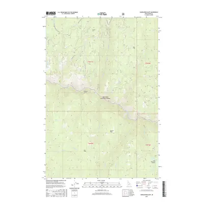
2017 Map of Huddleson Bluff
USGS Topo · Published 2017About this map
Nez Perce National Forest dominates this section of Idaho County, where the South Fork Clearwater River carves a deep path through the mountain terrain. Rising above the river's north bank, Huddleson Bluff serves as a prominent landmark for navigating the drainage systems of Peasley Cr and Medicine Creek. The landscape is defined by a series of high divides, including Rainbold Ridge and Blue Ridge, which separate various tributaries. To the southeast, Lower Twentymile Meadows provides a distinct break in the topography along Twentymile Cr. This survey illustrates the intricate network of forest development roads, such as Peasley Creek Rd and Quartz Ridge Rd, which provide access to remote areas like Bear Springs and the heights of Cougar Mtn. The map preserves the specific drainage patterns and ridge names critical for understanding the historical land management of this wilderness region.
Find a feature on this map
34 named features on this map. Tap any name to fly to it.
Don’t see what you’re looking for? This feature index may not catch every label — zoom into the map to look around manually.
Map Details
Editions of this 2017 Huddleson Bluff Map
This is the sole edition of this map. No revisions or reprints were ever made.
Other maps of this area

1931 · Buffalo Hump
USGS Topo · 1:125,000

1934 · Buffalo Hump
USGS Topo · 1:125,000

1956 · Elk City
USGS Topo · 1:250,000

1960 · Elk City
USGS Topo · 1:250,000

1962 · Golden
USGS Topo · 1:24,000

1962 · Pilot Knob
USGS Topo · 1:24,000

1963 · Sourdough Peak
USGS Topo · 1:24,000

1963 · Huddleson Bluff
USGS Topo · 1:24,000
1963 · Hungry Ridge
USGS Topo · 1:24,000
1963 · Corral Hill
USGS Topo · 1:24,000