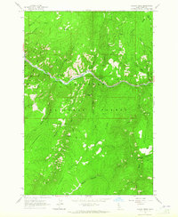
1963 Map of Hungry Ridge
USGS Topo · Published 1965About this map
The South Fork Clearwater River carves a deep path through the heart of the Nez Perce National Forest, serving as the primary corridor for movement and early infrastructure in this part of Idaho. At this time, the riverside is dotted with administrative and recreational outposts, including the South Fork Clearwater Station and Castle Creek Work Center. The presence of the Fisher Mine and Asbestos Mine Point suggests the era's ongoing interest in the mineral potential of the surrounding ridges. Higher elevations reveal a landscape managed for both utility and survival, from the Lookout Tower on Quartz Ridge to remote dwellings like the Barton Spring Cabin and Moore Ranch. The network of drainage systems, such as Johns Creek and American River, dictates the rugged layout of the terrain and the placement of early Jeep Trails.
Find a feature on this map
42 named features on this map. Tap any name to fly to it.
Don’t see what you’re looking for? This feature index may not catch every label — zoom into the map to look around manually.
Map Details
Editions of this 1963 Hungry Ridge Map
2 editions found
Other maps of this area

1931 · Buffalo Hump
USGS Topo · 1:125,000

1934 · Buffalo Hump
USGS Topo · 1:125,000

1955 · Grangeville
USGS Topo · 1:250,000

1956 · Elk City
USGS Topo · 1:250,000

1959 · Grangeville
USGS Topo · 1:250,000

1960 · Elk City
USGS Topo · 1:250,000
1963 · Sourdough Peak
USGS Topo · 1:24,000
1963 · Goodwin Meadows
USGS Topo · 1:24,000
1963 · Huddleson Bluff
USGS Topo · 1:24,000

1963 · Grangeville East
USGS Topo · 1:24,000