
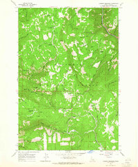
1963 Map of Goodwin Meadows
USGS Topo · Published 1964About this map
Snow Haven Ski Area and its early ski lifts define the northern highlands of this area within the Nez Perce National Forest. The landscape is a complex network of high ridges and deep drainages, where the South Fork Clearwater River cuts through the northeast corner, joined by Earthquake Creek. Civil infrastructure is sparse, characterized by remote outposts and seasonal camps such as Tollgate Ranch, White Bird Station, and Twin Cabins.
Find a feature on this map
57 named features on this map. Tap any name to fly to it.
Don’t see what you’re looking for? This feature index may not catch every label — zoom into the map to look around manually.
Map Details
Editions of this 1963 Goodwin Meadows Map
2 editions found
Other maps of this area

1931 · Buffalo Hump
USGS Topo · 1:125,000

1934 · Buffalo Hump
USGS Topo · 1:125,000

1955 · Grangeville
USGS Topo · 1:250,000

1956 · Elk City
USGS Topo · 1:250,000

1959 · Grangeville
USGS Topo · 1:250,000

1960 · Elk City
USGS Topo · 1:250,000

1963 · McKinzie Creek
USGS Topo · 1:24,000

1963 · Grangeville West
USGS Topo · 1:24,000

1963 · White Bird Hill
USGS Topo · 1:24,000
1963 · Hungry Ridge
USGS Topo · 1:24,000