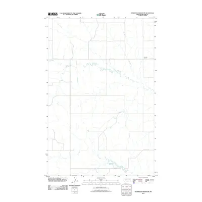
2011 Map of Hudiburgh Reservoir
USGS Topo · Published 2011About this map
Hudiburgh Reservoir and its associated Hudiburgh Dam anchor this segment of the Montana plains, illustrating the critical role of water management in McCone County. The landscape is defined by the winding paths of Cow Creek and Duck Creek, which carve through the terrain alongside an established network of rural infrastructure. For those researching local history, the Cow Creek Cemetery is a significant genealogical landmark, situated near Cow Creek Rd. Smaller water features like Vine Reservoir further emphasize the ranching and agricultural focus of the region. The grid-like layout of section lines and gravel roads such as North Rd and L-N Rd reveals the organized land divisions that have persisted through the early twenty-first century.
Find a feature on this map
11 named features on this map. Tap any name to fly to it.
Don’t see what you’re looking for? This feature index may not catch every label — zoom into the map to look around manually.
Map Details
Editions of this 2011 Hudiburgh Reservoir Map
This is the sole edition of this map. No revisions or reprints were ever made.
Other maps of this area

1954 · Glendive
USGS Topo · 1:250,000

1957 · Glendive
USGS Topo · 1:250,000

1958 · Glendive
USGS Topo · 1:250,000

1983 · Haynie Reservoir
USGS Topo · 1:24,000

1983 · Hudiburgh Reservoir
USGS Topo · 1:24,000

1983 · Dailey Spring
USGS Topo · 1:24,000

1983 · Hudiburgh Reservoir NW
USGS Topo · 1:24,000

1983 · Buffalo Creek
USGS Topo · 1:24,000

1983 · Beery Reservoir
USGS Topo · 1:24,000
1983 · Lone Pine School
USGS Topo · 1:24,000