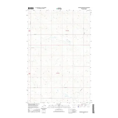
2017 Map of Hudiburgh Reservoir
USGS Topo · Published 2017About this map
Cow Creek Cem sits in the northeastern corner of this landscape, offering a specific point of interest for genealogists and local historians tracing families in this part of McCone County. The terrain is defined by the drainage systems of Cow Creek in the north and Duck Creek to the south, the latter of which feeds into Hudiburgh Reservoir. A network of rural roads, including W Duck Creek Rd and Cow Creek Rd, provide access across the townships. The presence of Oil Field Svc Rd indicates the regional significance of resource extraction, while the surrounding grid of section lines and range markers like t23n r48e underscore the systematic land division of the Montana plains.
Find a feature on this map
17 named features on this map. Tap any name to fly to it.
Don’t see what you’re looking for? This feature index may not catch every label — zoom into the map to look around manually.
Map Details
Editions of this 2017 Hudiburgh Reservoir Map
This is the sole edition of this map. No revisions or reprints were ever made.
Other maps of this area

1954 · Glendive
USGS Topo · 1:250,000

1957 · Glendive
USGS Topo · 1:250,000

1958 · Glendive
USGS Topo · 1:250,000

1983 · Haynie Reservoir
USGS Topo · 1:24,000

1983 · Hudiburgh Reservoir
USGS Topo · 1:24,000

1983 · Dailey Spring
USGS Topo · 1:24,000

1983 · Hudiburgh Reservoir NW
USGS Topo · 1:24,000

1983 · Buffalo Creek
USGS Topo · 1:24,000

1983 · Beery Reservoir
USGS Topo · 1:24,000
1983 · Lone Pine School
USGS Topo · 1:24,000