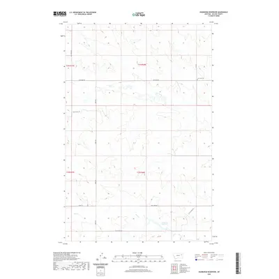
2020 Map of Hudiburgh Reservoir
USGS Topo · Published 2020About this map
Hudiburgh Reservoir and the drainage systems of Cow Creek and Duck Cr characterize this portion of McCone County. The landscape is defined by the section-line road network typical of the rural West, including North Rd and Cow Creek Rd, which provide access to this ranching and energy-producing region. Local history is anchored at the Cow Creek Cem in the northeastern quadrant, serving as a permanent record of the families who settled this area. Economic activity is evidenced by infrastructure like the Oil Field Svc Rd, showing the continued industrial utility of the land alongside traditional agricultural use. The terrain is marked by numerous draws and intermittent streams that feed into the larger reservoirs, illustrating the vital importance of water management in this part of Montana.
Find a feature on this map
17 named features on this map. Tap any name to fly to it.
Don’t see what you’re looking for? This feature index may not catch every label — zoom into the map to look around manually.
Map Details
Editions of this 2020 Hudiburgh Reservoir Map
This is the sole edition of this map. No revisions or reprints were ever made.
Other maps of this area

1954 · Glendive
USGS Topo · 1:250,000

1957 · Glendive
USGS Topo · 1:250,000

1958 · Glendive
USGS Topo · 1:250,000

1983 · Haynie Reservoir
USGS Topo · 1:24,000

1983 · Hudiburgh Reservoir
USGS Topo · 1:24,000

1983 · Dailey Spring
USGS Topo · 1:24,000

1983 · Hudiburgh Reservoir NW
USGS Topo · 1:24,000

1983 · Buffalo Creek
USGS Topo · 1:24,000

1983 · Beery Reservoir
USGS Topo · 1:24,000
1983 · Lone Pine School
USGS Topo · 1:24,000