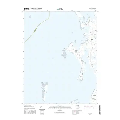
2016 Map of Hudson
USGS Topo · Published 2016About this map
Hudson and the small settlements of James and Thomas occupy the complex, water-broken shoreline of the Chesapeake Bay's eastern shore. This landscape is defined by its deep integration with the estuary, where land masses like Casson Neck and Hills Point Neck are nearly bisected by tidal inlets such as Brooks Creek and Hudson Creek. The map illustrates a coastal economy reliant on both land and sea, evidenced by small private airfields like Big Oak Farm Airport and Ragged Island Airport positioned alongside maritime infrastructure. Offshore, the remnants of James Island and Ragged Island stand in the Chesapeake Bay, marking the ongoing transformation of the shoreline. The intricate network of local roads, including Hudson Wharf Rd and Cooks Point Rd, connects isolated points and coves, reflecting the historic transport patterns of Dorchester County's waterfront communities.
Find a feature on this map
43 named features on this map. Tap any name to fly to it.
Don’t see what you’re looking for? This feature index may not catch every label — zoom into the map to look around manually.
Map Details
Editions of this 2016 Hudson Map
This is the sole edition of this map. No revisions or reprints were ever made.
Other maps of this area

1892 · Drum Point
USGS Topo · 1:62,500

1893 · Sharps Island
USGS Topo · 1:62,500

1898 · Choptank
USGS Topo · 1:125,000

1898 · St. Marys
USGS Topo · 1:125,000

1901 · Drum Point
USGS Topo · 1:62,500

1904 · Sharps Island
USGS Topo · 1:62,500

1904 · Oxford
USGS Topo · 1:62,500

1905 · Crapo
USGS Topo · 1:62,500

1905 · Drum Point
USGS Topo · 1:62,500

1906 · St. Marys
USGS Topo · 1:125,000