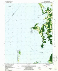
1982 Map of Hudson
USGS Topo · Published 1982About this map
Choptank River and Chesapeake Bay waters define this coastal portion of Dorchester County, where land and water meet in a complex network of points, coves, and tidal flats. The settlement of Hudson serves as a local hub near Covey Creek, while the community of Thomas sits further south along the shoreline of Brannock Bay. This 1982 orthophotomap combines traditional topographic data with aerial imagery, revealing the contemporary land use patterns of the era, from agricultural fields to the Landing Strip near James Point.
Find a feature on this map
38 named features on this map. Tap any name to fly to it.
Don’t see what you’re looking for? This feature index may not catch every label — zoom into the map to look around manually.
Map Details
Editions of this 1982 Hudson Map
This is the sole edition of this map. No revisions or reprints were ever made.
Other maps of this area

1892 · Drum Point
USGS Topo · 1:62,500

1893 · Sharps Island
USGS Topo · 1:62,500

1898 · Choptank
USGS Topo · 1:125,000

1898 · St. Marys
USGS Topo · 1:125,000

1901 · Drum Point
USGS Topo · 1:62,500

1904 · Sharps Island
USGS Topo · 1:62,500

1904 · Oxford
USGS Topo · 1:62,500

1905 · Crapo
USGS Topo · 1:62,500

1905 · Drum Point
USGS Topo · 1:62,500

1906 · St. Marys
USGS Topo · 1:125,000