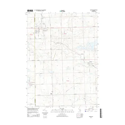
2014 Map of Hudson
USGS Topo · Published 2014About this map
The city of Hudson serves as the primary hub on this Lenawee County borderland, where the street grid fans out across the upper Bean Cr watershed. This 2014 survey captures the distinct transition between the concentrated urban settlement of Hudson and the surrounding agricultural landscape, characterized by a high density of rural cemeteries that mark the area's heritage. To the east, the sprawling Lake Hudson dominates the terrain, while the smaller hamlets of Medina and Lime Creek define the more southern reaches near the Hillsdale County line. The map reveals an intricate network of local drainage features such as Medina Drain and Henning Drain, essential for managing the low-lying farmland that surrounds these historic communities. For researchers, the abundance of burial grounds, including the Old Sacred Heart Church Cem and Maple Grove Cem, provides significant genealogical value for tracing the families of southern Michigan.
Find a feature on this map
85 named features on this map. Tap any name to fly to it.
Don’t see what you’re looking for? This feature index may not catch every label — zoom into the map to look around manually.
Map Details
Editions of this 2014 Hudson Map
This is the sole edition of this map. No revisions or reprints were ever made.
Other maps of this area

1911 · Wauseon
USGS Topo · 1:62,500

1913 · Wauseon
USGS Topo · 1:62,500

1913 · Alvordton
USGS Topo · 1:62,500

1943 · Wauseon
USGS Topo · 1:62,500

1944 · Alvordton
USGS Topo · 1:62,500

1953 · Fort Wayne
USGS Topo · 1:250,000

1956 · Fort Wayne
USGS Topo · 1:250,000

1960 · Morenci
USGS Topo · 1:24,000

1960 · Fayette
USGS Topo · 1:24,000
1961 · Alvordton
USGS Topo · 1:24,000